About Concord GO
Where Planning Began
To begin planning for a potential GO Station, the City of Vaughan adopted the Concord GO Centre Secondary Plan in June 2014. This plan established the policies that provide options for housing, employment, transit, shopping and recreation in Concord that would support development around a potential Concord GO Station. When the Concord GO Centre Secondary Plan was approved, York Region Council directed the City to undertake a Mobility Hub Study to put in place the policy framework to develop a complete community around a potential GO Station.
Concord GO Centre Secondary Plan (Official Plan Amendment 8)
A secondary plan is a planning document that establishes a more detailed policy context and implementation framework for the growth and development of a study area. Generally, the Concord GO Centre Secondary Plan allows for a mix of land uses near transit infrastructure. The permitted uses are:
- general employment
- prestige employment
- high-rise mixed-use
- commercial mixed-use
- low-rise mixed-use
- open space
- natural areas
On May 29, 2015, York Region Council decided to defer the Concord Go Centre Secondary Plan in two areas. Land uses in these areas were deferred pending the completion of the Mobility Hub Study.

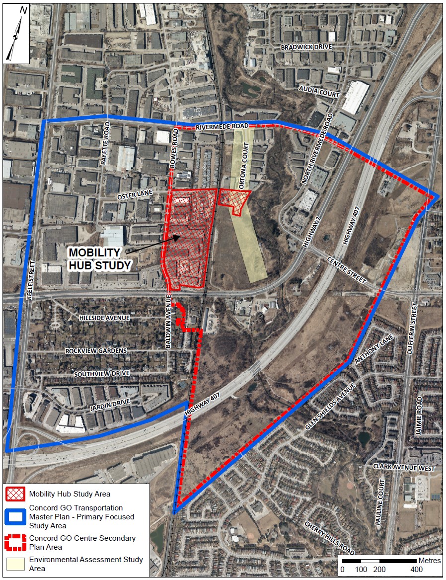
The Mobility Hub Study area is generally bound by Oster Lane to the north; Bowes Road to the west; the Barrie-GO rail line to the east with a portion of lands extending to Ortona Court; and Highway 7 to the south.
The boundaries of the Concord GO Transportation Master Plan are Langstaff Road to the north; Dufferin Street to the east; Keele Street to the west; and Highway 407 ETR to the south.
Current Land Uses
Highway 7 is in the centre of the study area. It currently consists mainly of low-density retail and commercial uses that are serviced by York Region Rapid Transit. The northern part of the study area, extending from Keele Street to Dufferin Street is made up of mostly smaller independent business and larger industrial uses, manufacturing and warehousing. The MacMillian CN Rail Yard is located to the west of the study area. The area south of Highway 7 is an established residential community known as Concord West. A mixed-use residential development is approved on the north side of Highway 7, east of the Barrie-GO Rail Line.
The Studies
To plan for a potential GO Station, the City is working on the following three studies at the same time:
- Mobility Hub Study
Transportation Master Plan
Schedule ‘C’ Environmental Assessment (EA) for a North-South Minor Collector Road from Rivermede Road to Highway 7
The Mobility Hub Study
This is a land-use study only for the deferred lands, which will guide the development of a complete community that is vibrant, inclusive and connected. A mobility hub provides a mix of land uses at different densities and options for transportation.
York Region’s Notice of Decision regarding the Concord GO Centre Secondary Plan (OPA 8) directed the City to undertake a Mobility Hub Study to pursue a potential GO Station. The Mobility Hub Study will:
review the identified deferral areas and establish a land-use planning policy framework with transit-supportive uses and densities.
review the deferral areas for potential opportunities for intensification that will support the development of a complete community.
develop a preferred land-use scenario, and the City’s preferred location for a potential future GO Station, to be tested through the Transportation Master Plan.
identify infrastructure needs to support a potential GO Station.
prepare the urban design guidelines to ensure the integration of the Mobility Hub to the broader Secondary Plan area.
The Transportation Master Plan
The Transportation Master Plan is a transportation planning study that will evaluate existing and future transportation conditions within the Concord GO Secondary Plan area, identify transportation needs and evaluate different options for the transportation network. This work will support anticipated growth in the area, while providing strong connections to regional and local transit systems.
The City is required to undertake a Transportation Master Plan to create connectivity for the Concord GO Secondary Plan area by:
studying the opportunity to establish a road connection between Highway 7 and Rivermede Road.
studying the feasibility of an east-west grade-separated road crossing the GO Barrie rail line.
studying opportunities for active transportation and connecting to existing facilities.
The main objectives of the Transportation Master Plan are to:
test several scenarios for land use/built form developed through the Mobility Hub Study and a location for a potential GO Station.
select the preferred alternative based on the analysis results.
update transportation policies/plans in the Secondary Plan to reflect the preferred alternative.
The Schedule ‘C’ Environmental Assessment (EA) Study
Upon completion of the Transportation Master Plan, this study will advance the planning and design of a new north-south minor collector road from Rivermede Road to Highway 7, determining the road’s preferred right-of-way and alignment. This study will follow the Municipal Class Environmental Assessment process, as a Schedule ‘C’. As such, it will undertake Phase 3 (Design of Preferred Alternative) and Phase 4 (Environmental Study Report – ESR) of the Municipal Class Environmental Assessment process and will find ways to help minimize impacts to the natural environment, and the social and cultural realm.
The findings of all three studies will be used as inputs to support the approval of the potential Concord GO Station.
To learn more about the Concord GO Centre, read the frequently asked questions.
