Block 27 Environmental Assessment
Project Completion
An Environmental Study Report (ESR) has been prepared to document the study process, consultation efforts and the recommended collector network plan for Block 27. The Notice of Completion places the ESR on public record for review for 30 days beginning October 29th, 2024, and ending November 29th, 2024. The Notice of Completion can be download at the following link. Please review the Notice for details on providing questions and comments on the ESR. Comments and questions can be sent directly to the project team.
The appendices related to the ESR can be downloaded below for your reference.
Block 27 Environmental Assessment
In the plan, it was recommended that the City builds a network of collector roads that considers auto, transit, cycling and pedestrian needs for Block 27 to accommodate both existing residents and new residents to 2031 and beyond. A collector road is a medium-sized municipal street(s) that connect the main street network to the local street network. Collectors are characterized by a balance of access and mobility.
The Block 27 Collector Roads Municipal Class Environmental Assessment will complete the remaining Phase 3 and Phase 4 processes, building on the completion of Phase 1 and Phase 2 conducted through the North Vaughan and New Communities Transportation Master Plan.
Phase 3: Generate alternative designs for the preferred solution from the North Vaughan and New Communities Transportation Master Plan.
Phase 4: Complete the Environmental Study Report, which brings together the existing conditions review, future conditions analysis, alternative solutions and designs, the preferred design solution and implementation and mitigation measures.
The Study Area

Join the conversation!
On Nov. 16, 2022, the City held a live, virtual Public Information Centre to share information with the community about the new local street network planned for Block 27. Following the event, community members were invited to submit questions and comments from Nov. 17 to Nov. 30, 2022. View the presentation (PDF) or watch a video recording of the presentation below. Thank you to those who participated! Responses to the questions received during the comment period are provided below.
Frequently Asked Questions
-
Answer
The Block 27 EA is being conducted by the City and the Block 27 Landowners Group. The Block 27 EA is a direct continuation of the Block 27 Secondary Plan and NVNCTMP, where the Block 27 EA will complete the remaining phases of the Environmental Assessment process. The NVNCMTP completed Phases 1 and 2, and the Block 27 EA will complete Phases 3 and 4.
The Block 27 EA builds on the recommendations of the NVNCMTP and Block 27 Secondary Plan, with a focus on optimizing and refining the recommended transportation network. The Block 27 EA is not investigating significant changes to the Secondary Plan transportation network.
Read the Block 27 Secondary Plan and NVNCTMP webpages for more information on these projects.
-
Answer
The Kirby Road improvements have been considered and will be incorporated into the detailed design of the Block 27 transportation network. This includes the design of all intersections along Kirby Road between Jane Street and Keele Street. The Block 27 transportation network will not prevent or affect the improvements recommended as part of the Kirby Road improvements process. For more information on the Kirby Road improvements, visit vaughan.ca/KirbyWidening.
-
Answer
The Kirby Road Widening Environmental Assessment is complete, and the next stage of the process is detailed design. Implementation will follow the detailed design stage. However, exact timelines cannot be estimated at this point. To follow this project as it progresses, please visit vaughan.ca/KirbyWidening.
-
Answer
The recommended transportation network for Block 27 does not include a connection or continuation of Peak Point Boulevard to the west of Keele Street. As a result, Block 27 will not create any new opportunities for cut-through traffic within the Peak Point Boulevard neighbourhood.
-
Answer
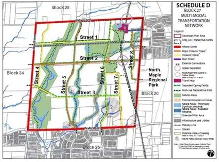
The Block 27 Secondary Plan and NVMCTMP recommend three new intersections on Keele Street at Vista Gate, Street 2 and Street 8 (see Study Area map above). The project team is paying close attention to these proposed new intersections. Traffic forecasts on Keele Street indicate that the intersections will be adequately spaced to mitigate queueing issues and will maintain acceptable traffic operations.
-
Answer
The Block 27 Secondary Plan and NVNCTMP recommended a connection at Vista Gate on Keele Street to facilitate access to the future Kirby GO Station. As a result, the connection to Vista Gate will be important for the Block. While the Vista Gate intersection is closely spaced to Kirby Road, current traffic forecasts reveal that this intersection will benefit traffic flows on Keele Street by breaking up the existing northbound queues leading to Kirby Road. Introducing a connection to Peak Point Boulevard is not recommended as this connection would impact existing natural features to the west of Keele Street. Additionally, City staff determined the connection to Peak Point Boulevard is not also required to accommodate traffic in the area.
-
Answer
Though the Block 27 EA, staff are carefully reviewing all intersections along the boundary road network to ensure sufficient spacing. Where needed, staff may make slight adjustments to these intersection locations to increase the spacing as the traffic forecasting is reviewed. As these boundary roads are managed by York Region, City staff are working with the Region to explore options to increase intersection spacing, such as at the intersection of Street 7 (see Study Area map above) and Keele Street.
-
Answer
Through the Block 27 Secondary Plan and NVNCMTP process, the City assessed the feasibility of providing two east-west collector roads. Through that review, staff determined that only one east-west collector road would be technically feasible due to geographic constraints such as the rail corridor, location of natural features and the planned location of the future Kirby GO Station. A second east-west road would require a second grade separation to cross the rail corridor, and this is not safe or feasible due to the area’s slope.
-
Answer
Option 1C for Street 1 (see Study Area map above) would be the least impactful to properties. That said, as part of the EA process, City staff were required to evaluate and balance multiple criteria. Additional criteria identified through the EA process, such as environmental impact, structural requirements for the greenbelt crossing, cost of construction and maintenance, and potential for accommodating future land uses in the Block, outweighed property impacts when selecting the preferred alignment.
-
Answer
Option 5A is the preliminary preferred alignment for Street 5 (see Study Area map above). With this alignment, Street 5 starts west of the natural heritage and wetland features near Teston Road, proceeds northbound, and ultimately intersects with Kirby Road. Option 5A follows the alignment recommended in the Secondary Plan, with the exception of a slight shift east at the intersection of Street 5 and Street 2 (see Study Area map above). The intersection of Street 5 with Kirby Road remains the same as what was recommended in the Secondary Plan.
-
Answer
York Region is undertaking an Individual Environmental Assessment (IEA) to examine transportation improvements in the Teston Road area between Highway 400 to Bathurst Street and between Major Mackenzie Drive and Kirby Road. This IEA will study the potential for a grade separation (underpass or overpass) on Teston Road at the rail crossing. To learn more about the Teston Road IEA, you can visit the Teston Road IEA webpage.
With respect to the rail crossing at Kirby Road, an underpass (rail over road) was the preferred GO rail crossing alternative as evaluated under the Kirby Road Widening EA study.
-
Answer
Metrolinx is responsible for the design and construction of Kirby GO Station. At this time, the City does not have information on when the station will be built. The Block 27 EA is planning the transportation network in a way that will protect for the station’s eventual construction.
-
Answer
Work is currently underway to finalize the preliminary preferred transportation network. The project team is continuing to consult with interested agencies and stakeholders to finalize the recommended transportation network. Upon finalizing the preliminary preferred transportation network, an Environmental Study Report (ESR) will be prepared and distributed for public review. A notice of the ESR public review period will be issued to all properties within Block 27 and the surrounding area, as well as to those who have registered for email updates. To register for project updates, please email the project team at Block27EA@vaughan.ca. Additionally, it will be posted on this webpage. Following this review period, the ESR and its recommendations will be presented to Vaughan Council before it is submitted for review to the Ministry of the Environment, Conservation and Parks.
-
Answer
At this time, the City cannot provide an anticipated timeline for construction.
-
Answer
Once the ESR is prepared, there will be a public review period. The public will be notified through a notice that will be issued to all properties within Block 27 and the surrounding area and those who have registered for email updates. To register for project updates, please email the project team at Block27EA@vaughan.ca. Additionally, it will be posted on this webpage.
In addition, alongside the Block 27 EA, the Block 27 Landowners Group is also undergoing the City’s Block Plan process. The Block Plan process is required to coordinate the delivery of infrastructure and services throughout the Block. Through the Block Plan process, there will be opportunities for public engagement. A notice will be mailed to all properties within the Block 27 area and posted in the Vaughan Citizen.


